fbpx
Loading...Loading Park Alerts...

Park Alerts (6)

***Discover Our Parks, LLC takes no responsability in the accuracy of these alerts, which are taken directly from NPS.gov, and we provide them for informational purposes only. Please refer to NPS.gov for more information.

Cuyahoga Valley National Park Maps & Documents

These maps are for general use only. Please read nps.gov's Data Sources and Accuracy statement for more information.
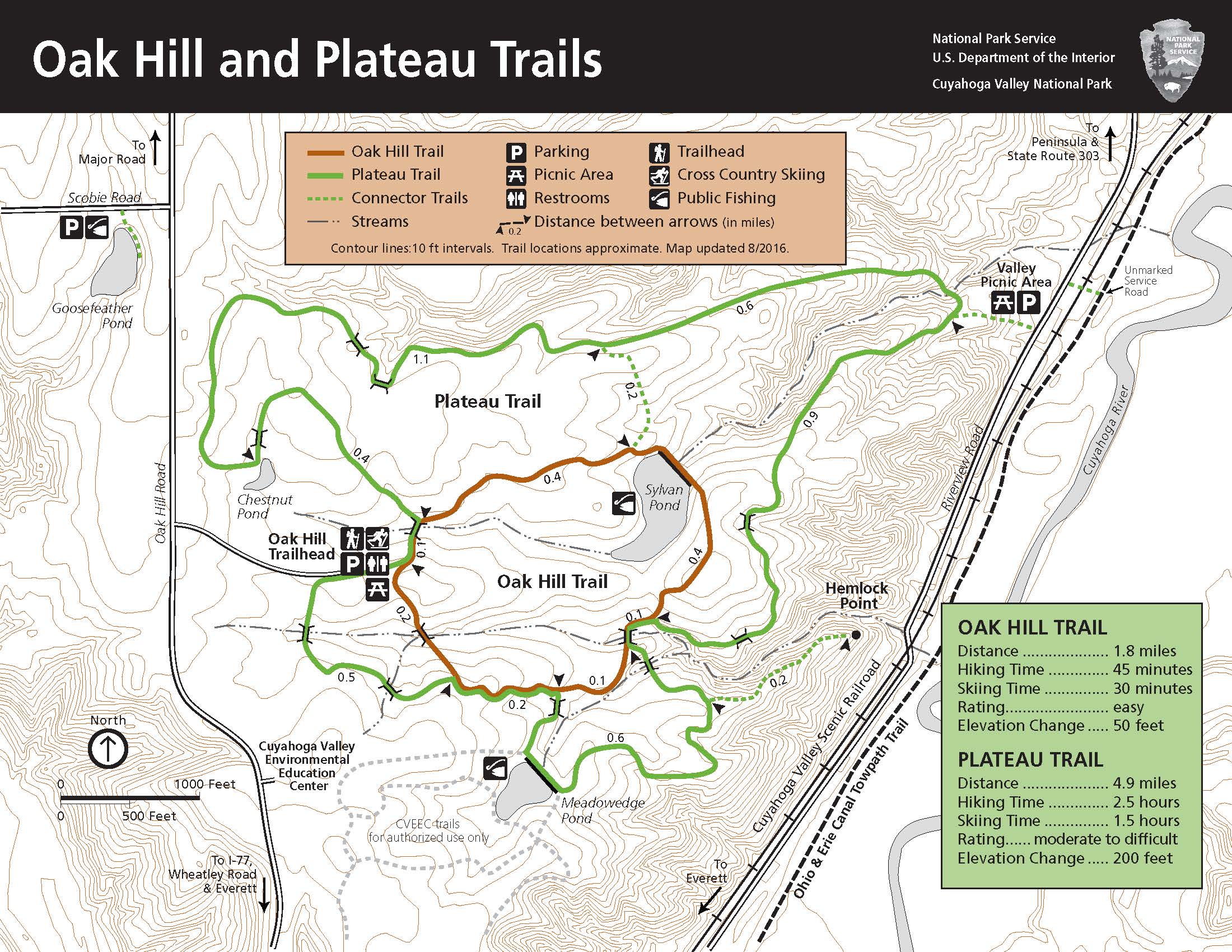
A Map Of The 1.8 Mile Oak Hill Trail And The 4.6 Mile Plateau Trail. Both Are Loop Trails Off Of Oak Hill Road At Oak Hill Trailhead. The Trailhead Has Parking, Restrooms, Picnic Tables, And The Trails Can Be Used To Cross Country Ski In The Winter. - A map of the 1.8 mile Oak Hill Trail and the 4.6 mile Plateau trail. Both are loop trails off of Oak Hill Road at Oak Hill Trailhead. The trailhead has parking, restrooms, picnic tables, and the trails can be used to cross country ski in the winter.
A Map Of The 1.8 Mile Oak Hill Trail And The 4.6 Mile Plateau Trail. Both Are Loop Trails Off Of Oak Hill Road At Oak Hill Trailhead. The Trailhead Has Parking, Restrooms, Picnic Tables, And The Trails Can Be Used To Cross Country Ski In The Winter.
A map of the 1.8 mile Oak Hill Trail and the 4.6 mile Plateau trail. Both are loop trails off of Oak Hill Road at Oak Hill Trailhead. The trailhead has parking, restrooms, picnic tables, and the trails can be used to cross country ski in the winter.
Map file from NPS.gov/meve/ website
3.20 MB

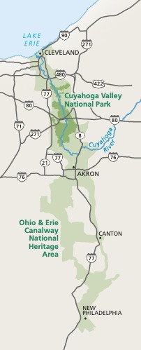
A Map Of The Area Of Cuyahoga Valley National Park (CVNP) As Well As The Areas Immediately Surrounding It. - A map of the area of Cuyahoga Valley National Park (CVNP) as well as the areas immediately surrounding it.
A Map Of The Area Of Cuyahoga Valley National Park (CVNP) As Well As The Areas Immediately Surrounding It.
A map of the area of Cuyahoga Valley National Park (CVNP) as well as the areas immediately surrounding it.
Map file from NPS.gov/cuva/ website
23.64 KB

A Map Of The Area Of Cuyahoga Valley National Park (CVNP), Ohio & Erie Canalway National Heritage Area, As Well As The Areas Immediately Surrounding Both The Park And The National Heritage Area. - A map of the area of Cuyahoga Valley National Park (CVNP), Ohio & Erie Canalway National Heritage Area, as well as the areas immediately surrounding both the park and the National Heritage Area.
A Map Of The Area Of Cuyahoga Valley National Park (CVNP), Ohio & Erie Canalway National Heritage Area, As Well As The Areas Immediately Surrounding Both The Park And The National Heritage Area.
A map of the area of Cuyahoga Valley National Park (CVNP), Ohio & Erie Canalway National Heritage Area, as well as the areas immediately surrounding both the park and the National Heritage Area.
Map file from NPS.gov/whsa/ website
35.19 KB

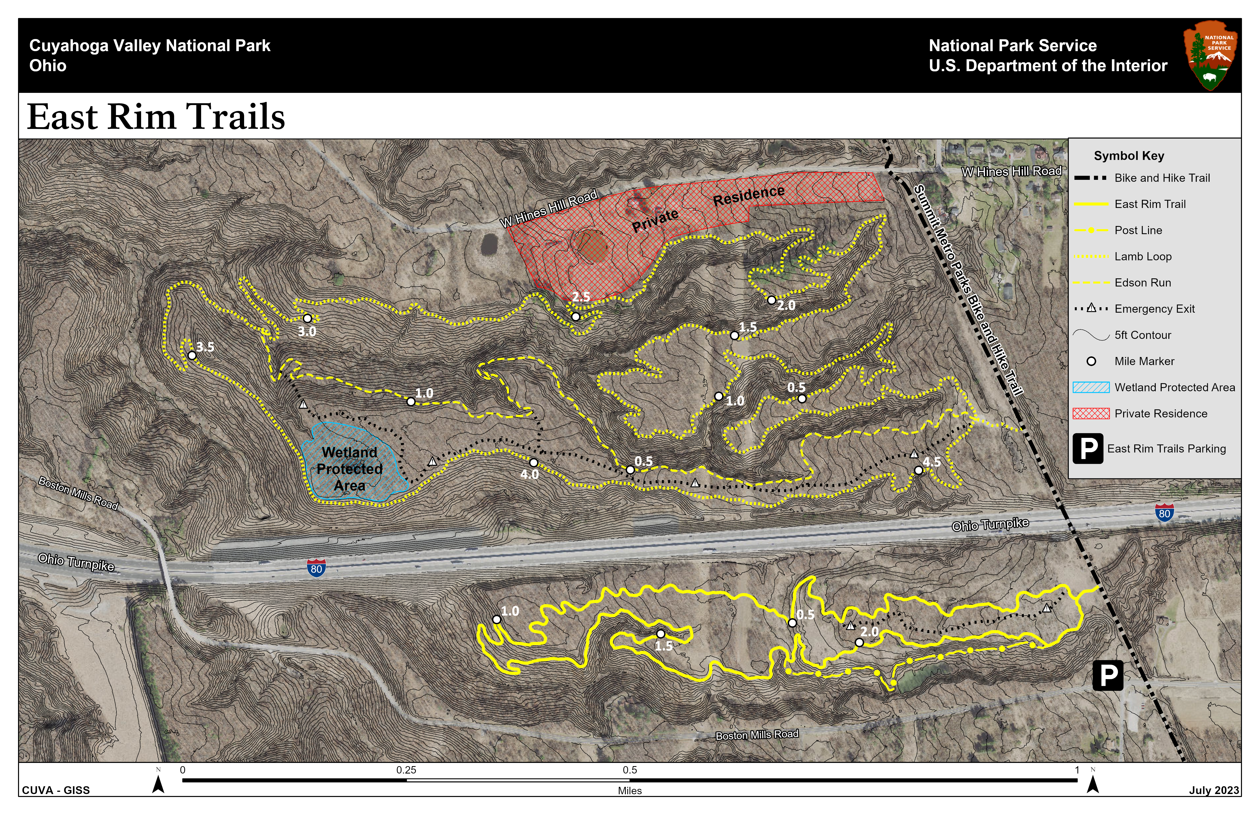
A Map Of The East Rim Trail System, A 2.3-mile East Rim Trail, 4.7-mile Lamb Loop, And 1.3-mile Edson Run. - A map of the East Rim trail system, a 2.3-mile East Rim Trail, 4.7-mile Lamb Loop, and 1.3-mile Edson Run.
A Map Of The East Rim Trail System, A 2.3-mile East Rim Trail, 4.7-mile Lamb Loop, And 1.3-mile Edson Run.
A map of the East Rim trail system, a 2.3-mile East Rim Trail, 4.7-mile Lamb Loop, and 1.3-mile Edson Run.
Map file from NPS.gov/cuva/ website
1.70 MB

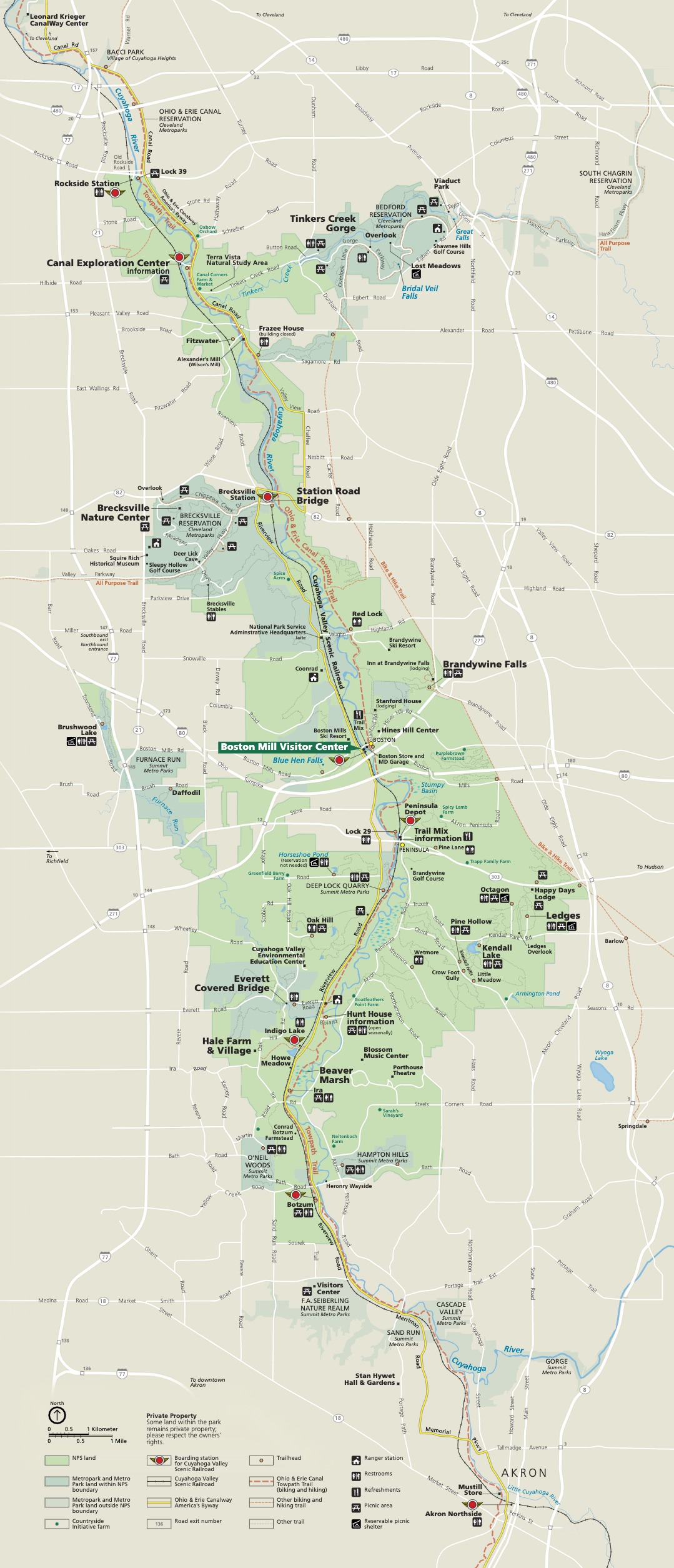
A Map Of The Entire Area Of Cuyahoga Valley National Park (CVNP). The Boundaries And Interior Of The Area Designated To CVNP Are Colored A Light Green. Markers Indicate Destinations Across The Park As Well As Various Amenities And Roadways. - A map of the entire area of Cuyahoga Valley National Park (CVNP). The boundaries and interior of the area designated to CVNP are colored a light green. Markers indicate destinations across the park as well as various amenities and roadways.
A Map Of The Entire Area Of Cuyahoga Valley National Park (CVNP). The Boundaries And Interior Of The Area Designated To CVNP Are Colored A Light Green. Markers Indicate Destinations Across The Park As Well As Various Amenities And Roadways.
A map of the entire area of Cuyahoga Valley National Park (CVNP). The boundaries and interior of the area designated to CVNP are colored a light green. Markers indicate destinations across the park as well as various amenities and roadways.
Map file from NPS.gov/cuva/ website
510.87 KB

A Map Of The Entire Area Of Cuyahoga Valley National Park From Rockside Station In The North To Akron In The South. Markers Indicate Destinations Across The Park As Well As Various Amenities And Roadways. - A map of the entire area of Cuyahoga Valley National Park from Rockside Station in the North to Akron in the South. Markers indicate destinations across the park as well as various amenities and roadways.
A Map Of The Entire Area Of Cuyahoga Valley National Park From Rockside Station In The North To Akron In The South. Markers Indicate Destinations Across The Park As Well As Various Amenities And Roadways.
A map of the entire area of Cuyahoga Valley National Park from Rockside Station in the North to Akron in the South. Markers indicate destinations across the park as well as various amenities and roadways.
Map file from NPS.gov/gaar/ website
773.79 KB

Area Map - From park brochure
Area Map
From park brochure
JPG Viewable Map File
23.64 KB
2019 screen-viewable file
1.55 MB
2019 Adobe Illustrator print production file
1.79 MB
*downloads in a Zip file.

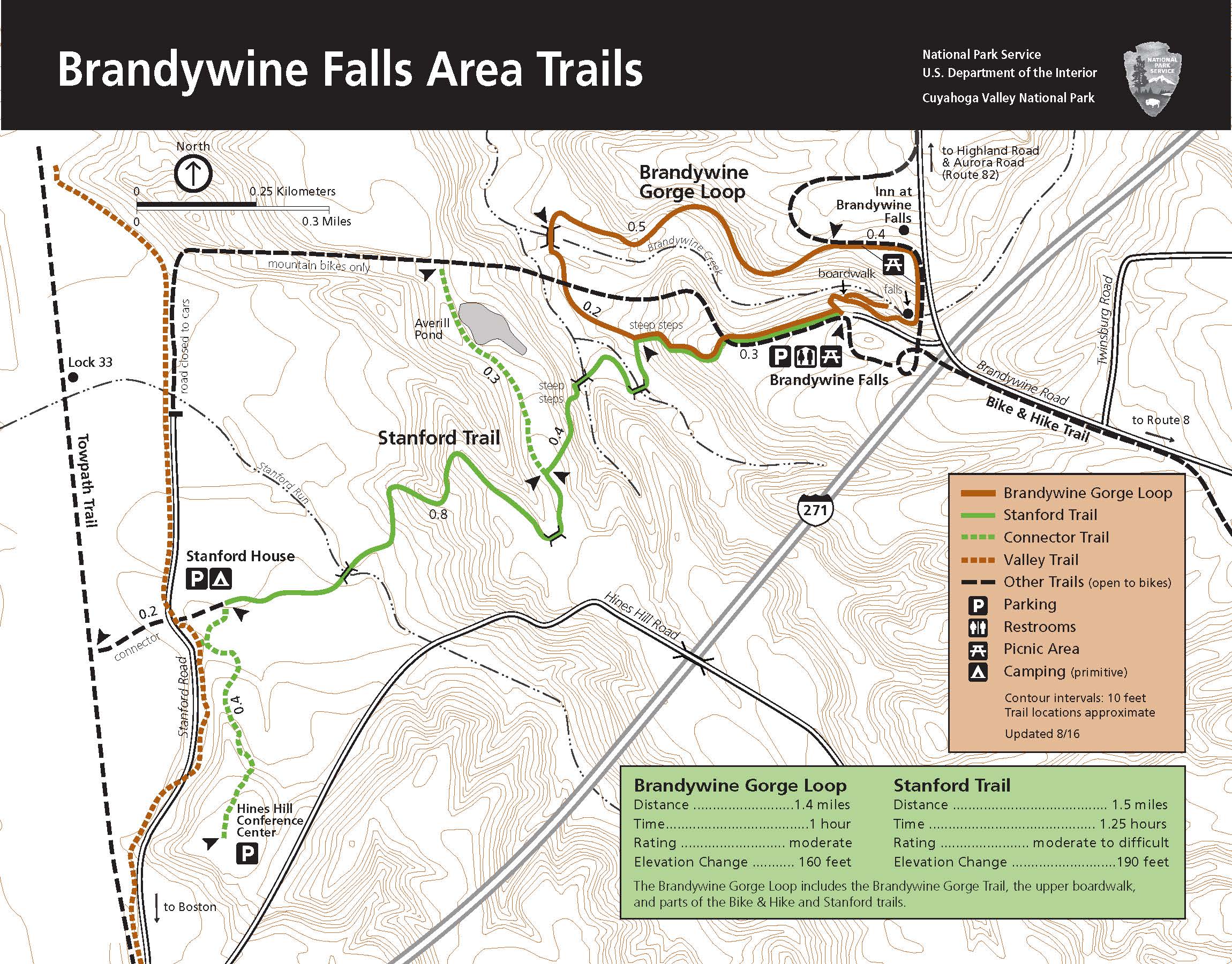
Area Map Of Brandywine Falls - Area map of Brandywine Falls
Area Map Of Brandywine Falls
Area map of Brandywine Falls
Map file from NPS.gov/cuva/ website
651.31 KB

Area Map Of Brandywine Falls Area Trails. - Area map of Brandywine Falls area trails.
Area Map Of Brandywine Falls Area Trails.
Area map of Brandywine Falls area trails.
Map file from NPS.gov/whsa/ website
38.42 KB

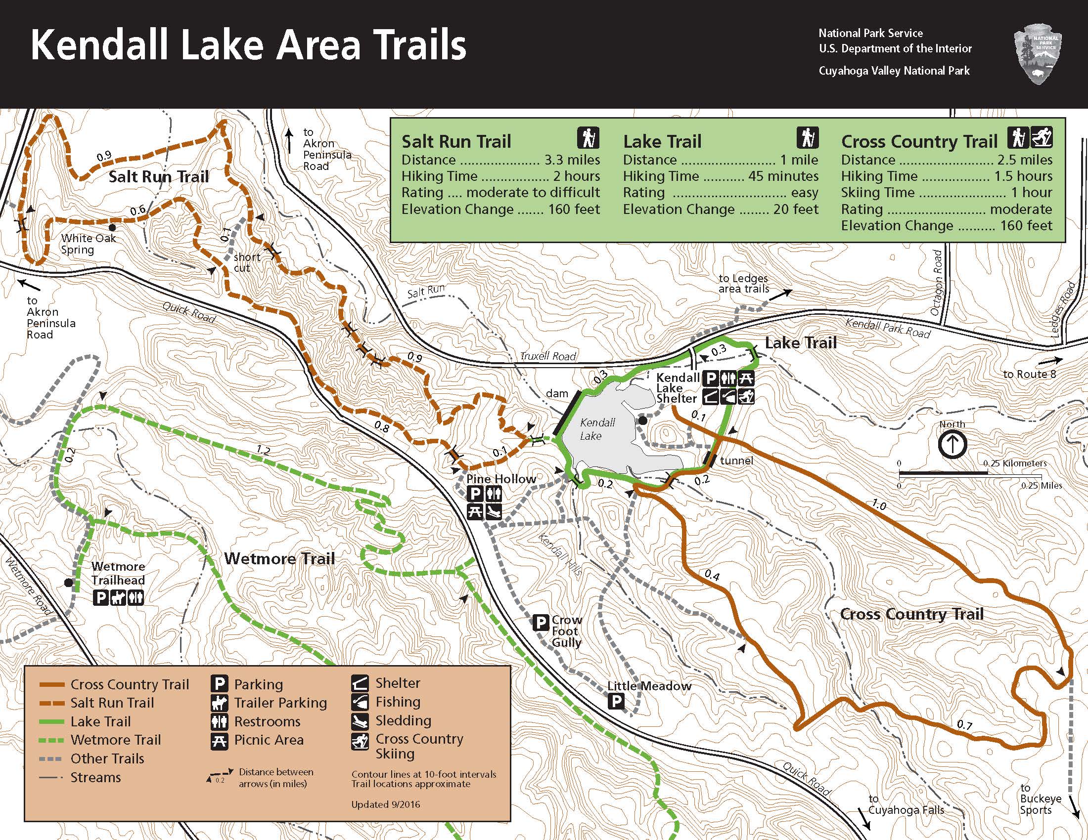
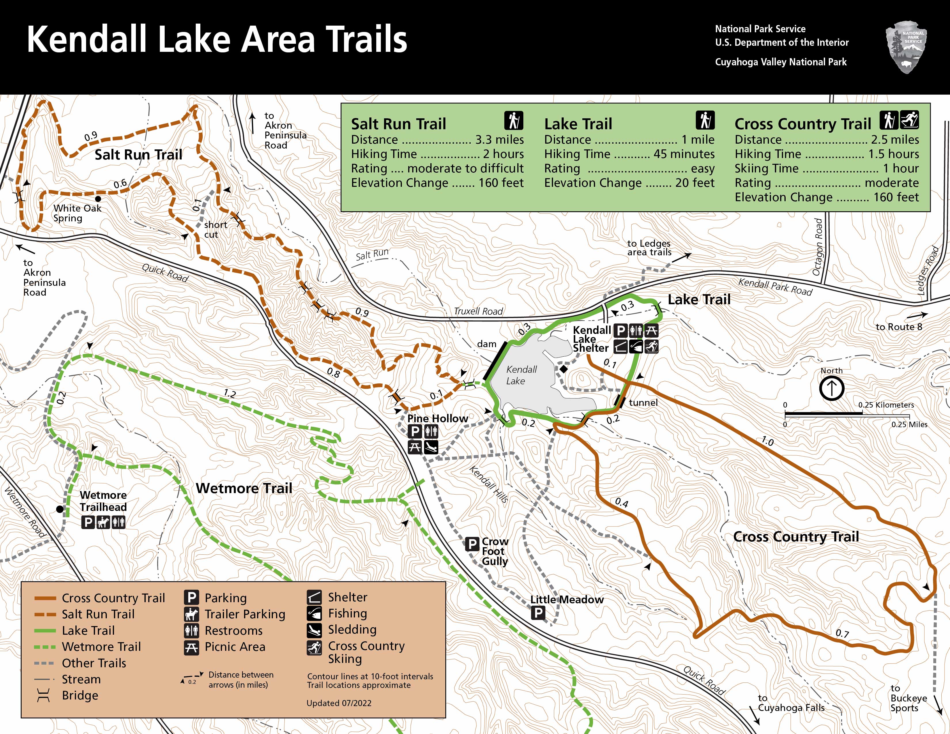
Area Map Of The Kendall Lake Trails. - Area map of the Kendall Lake trails.
Area Map Of The Kendall Lake Trails.
Area map of the Kendall Lake trails.
Map file from NPS.gov/cuva/ website
732.76 KB

Boston Run Trail Off State Route 303 Starts From The Happy Days Lodge Parking Lot. A 3.1-mile Loop With 80 Feet Elevation Change. Connect To Haskell Run And Ledges Trail For A Longer Hike. - Boston Run trail off State Route 303 starts from the Happy Days Lodge parking lot. A 3.1-mile loop with 80 feet elevation change. Connect to Haskell Run and Ledges Trail for a longer hike.
Boston Run Trail Off State Route 303 Starts From The Happy Days Lodge Parking Lot. A 3.1-mile Loop With 80 Feet Elevation Change. Connect To Haskell Run And Ledges Trail For A Longer Hike.
Boston Run trail off State Route 303 starts from the Happy Days Lodge parking lot. A 3.1-mile loop with 80 feet elevation change. Connect to Haskell Run and Ledges Trail for a longer hike.
Map file from NPS.gov/sagu/ website
2.41 MB

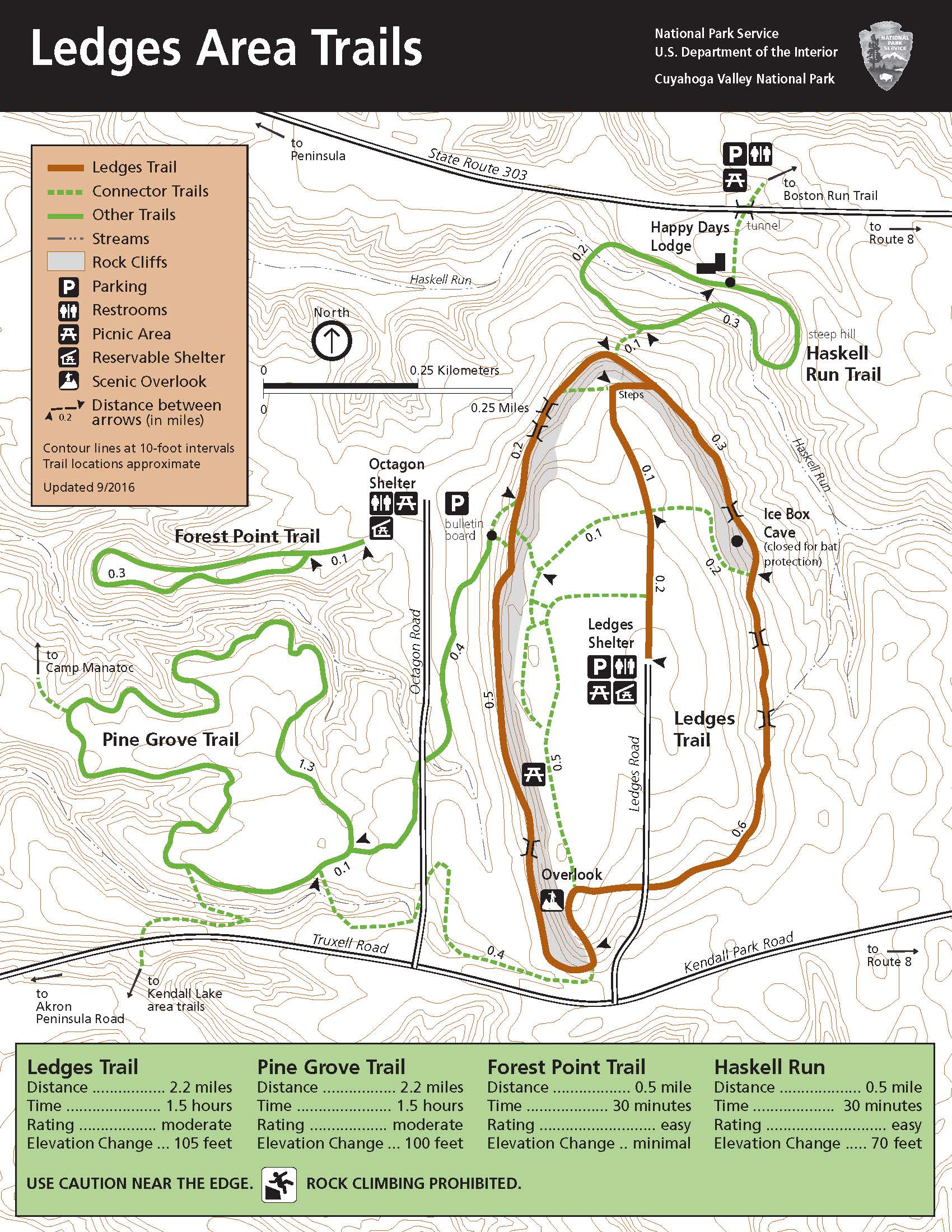
Ledges Trail, 2.2-mile Loop, 105 Feet Elevation Change, Steep Stairs. Pine Grove Trail, Via Octagon, 2.2-mile Loop, 100 Feet Elevation Change. Forest Point From Octagon, 0.5-mile Loop. Haskell Run Trail, 0.5-mile Loop, 70 Feet Elevation Change. - Ledges Trail, 2.2-mile loop, 105 feet elevation change, steep stairs. Pine Grove trail, via Octagon, 2.2-mile loop, 100 feet elevation change. Forest Point from Octagon, 0.5-mile loop. Haskell Run trail, 0.5-mile loop, 70 feet elevation change.
Ledges Trail, 2.2-mile Loop, 105 Feet Elevation Change, Steep Stairs. Pine Grove Trail, Via Octagon, 2.2-mile Loop, 100 Feet Elevation Change. Forest Point From Octagon, 0.5-mile Loop. Haskell Run Trail, 0.5-mile Loop, 70 Feet Elevation Change.
Ledges Trail, 2.2-mile loop, 105 feet elevation change, steep stairs. Pine Grove trail, via Octagon, 2.2-mile loop, 100 feet elevation change. Forest Point from Octagon, 0.5-mile loop. Haskell Run trail, 0.5-mile loop, 70 feet elevation change.
Map file from NPS.gov/sagu/ website
2.81 MB

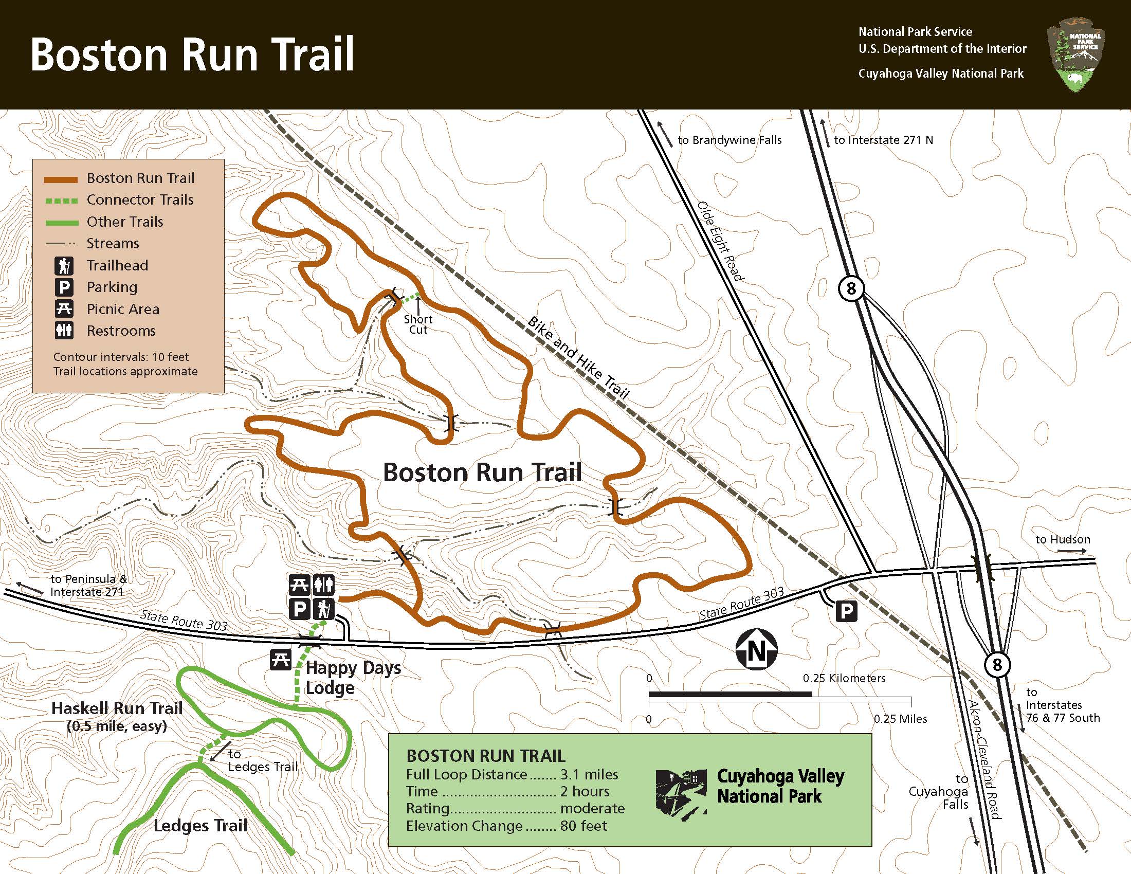
Map Of Boston Run Trail - Map of Boston Run Trail
Map Of Boston Run Trail
Map of Boston Run Trail
Map file from NPS.gov/cuva/ website
517.59 KB

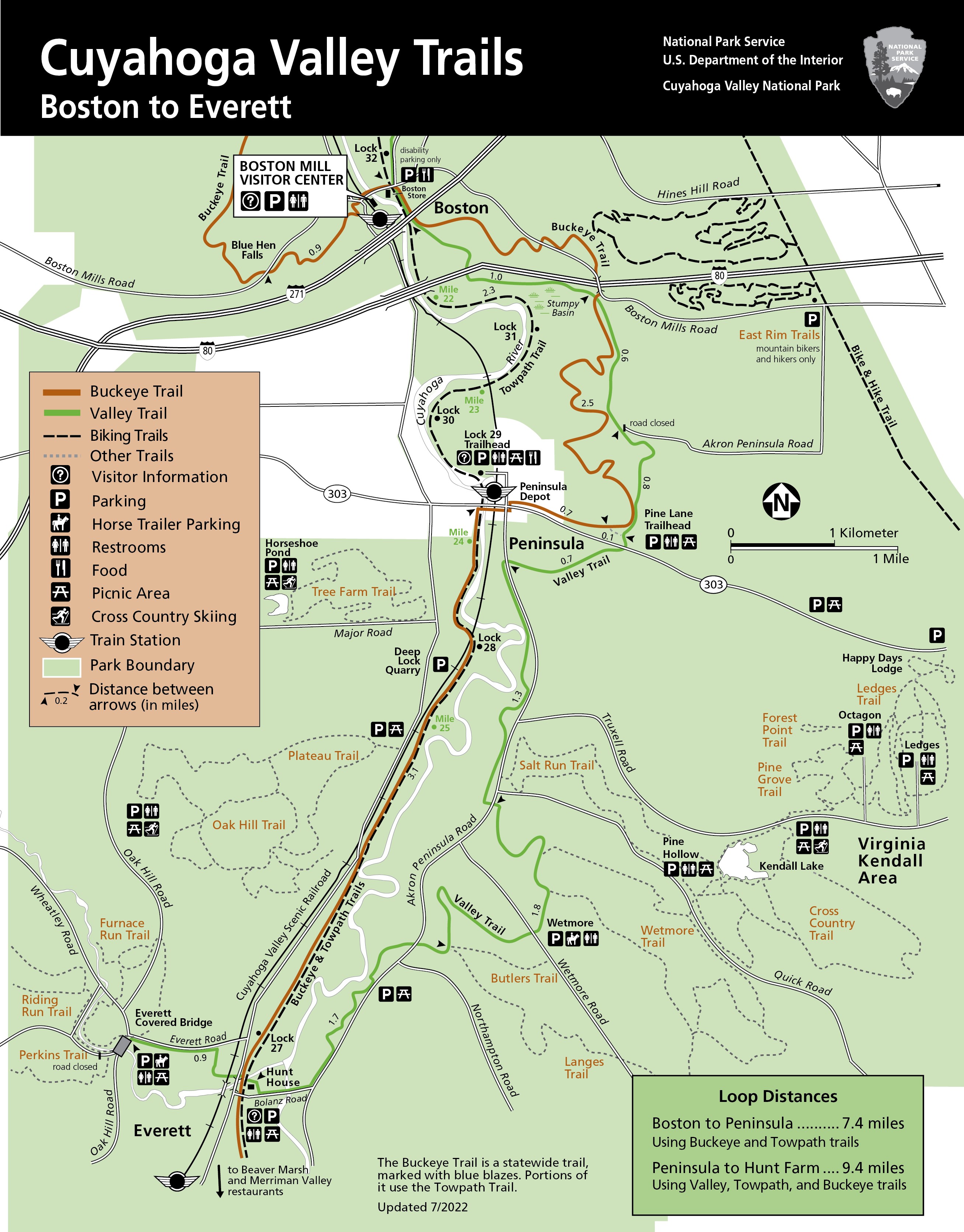
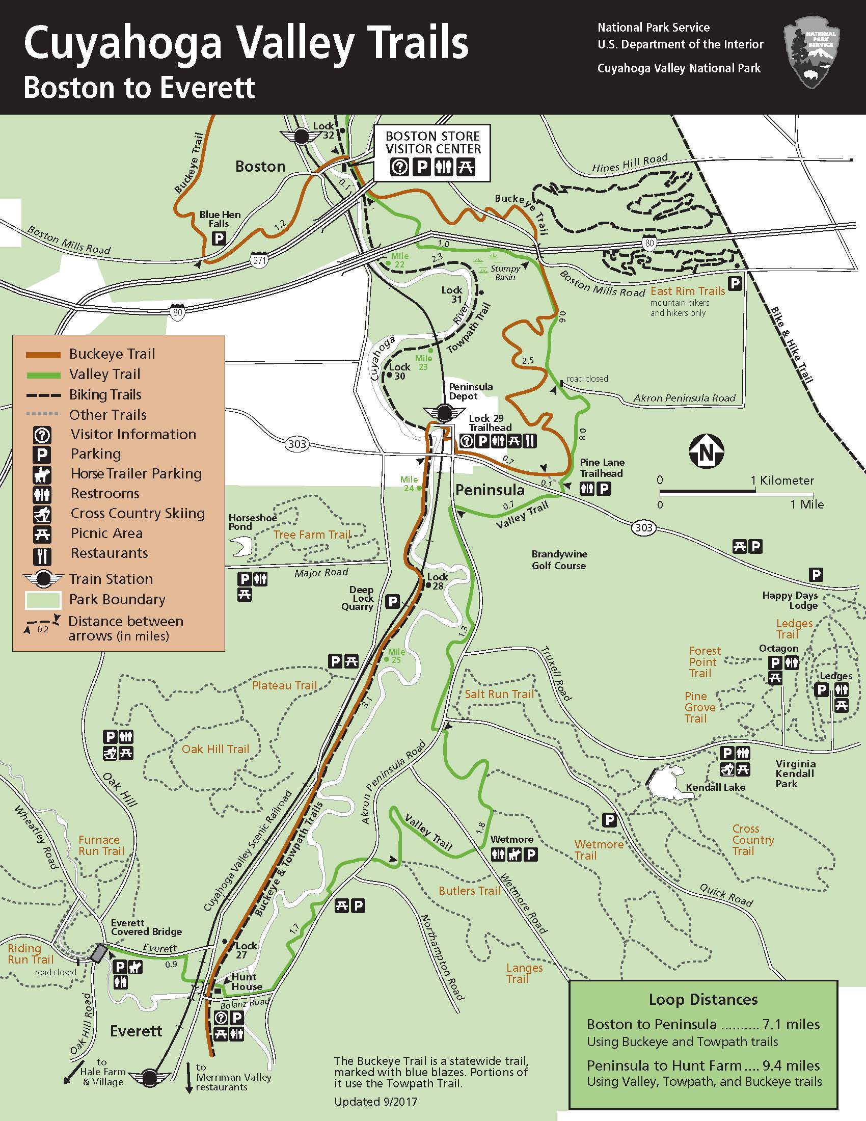
Map Of Cuyahoga Valley Trails From Boston To Everett. - Map of Cuyahoga Valley Trails from Boston to Everett.
Map Of Cuyahoga Valley Trails From Boston To Everett.
Map of Cuyahoga Valley Trails from Boston to Everett.
Map file from NPS.gov/cuva/ website
395.24 KB

Map Of The Cuyahoga Valley Trails From Boston To Everett - Map of the Cuyahoga Valley Trails from Boston to Everett
Map Of The Cuyahoga Valley Trails From Boston To Everett
Map of the Cuyahoga Valley Trails from Boston to Everett
Map file from NPS.gov/cuva/ website
442.92 KB

Map Of The Everett Area Trails. - Map of the Everett area trails.
Map Of The Everett Area Trails.
Map of the Everett area trails.
Map file from NPS.gov/cuva/ website
639.98 KB

Map Of The Ledges Area And Trails - Map of the Ledges area and trails
Map Of The Ledges Area And Trails
Map of the Ledges area and trails
Map file from NPS.gov/cuva/ website
577.81 KB

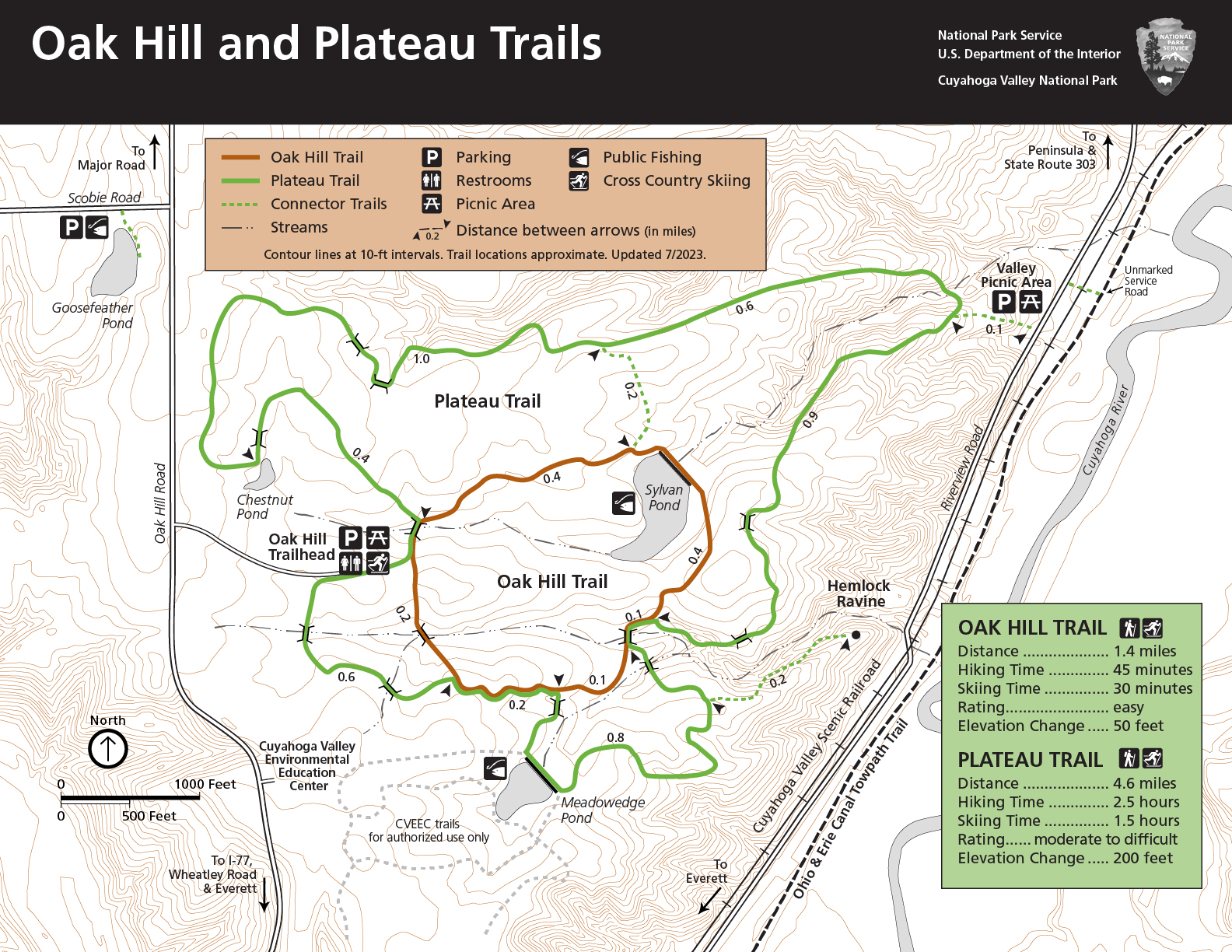
Map Of The Oak Hill Area Trails. - Map of the Oak Hill area trails.
Map Of The Oak Hill Area Trails.
Map of the Oak Hill area trails.
Map file from NPS.gov/cuva/ website
617.02 KB

Map Of The Station Road Area. - Map of the Station Road area.
Map Of The Station Road Area.
Map of the Station Road area.
Map file from NPS.gov/cuva/ website
475.17 KB

Map Of The Wetmore Area Trails. - Map of the Wetmore area trails.
Map Of The Wetmore Area Trails.
Map of the Wetmore area trails.
Map file from NPS.gov/cuva/ website
693.97 KB

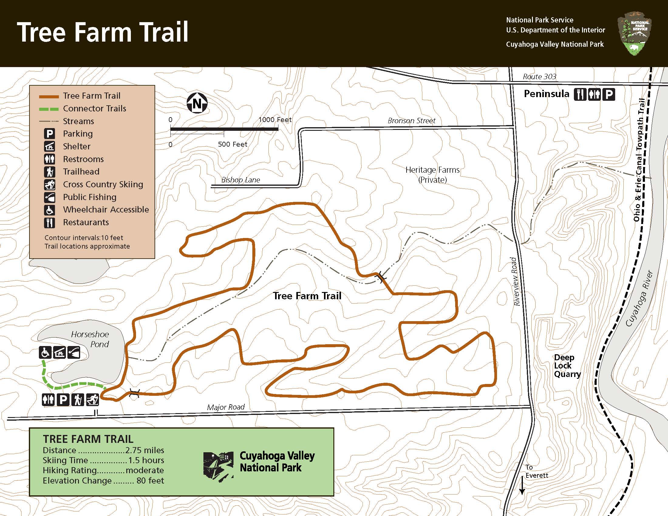
Map Of Tree Farm Trail. - Map of Tree Farm Trail.
Map Of Tree Farm Trail.
Map of Tree Farm Trail.
Map file from NPS.gov/cuva/ website
444.23 KB

Oak Hill Trail, 1.8-mile Loop, Easy Rating, 50 Feet Elevation Change. Plateau Trail, 4.9 Miles, Moderate To Difficult Rating, 200 Feet Elevation Change, Steep In Areas. Access The Trailhead Off Oak Hill Road. - Oak Hill Trail, 1.8-mile loop, easy rating, 50 feet elevation change. Plateau Trail, 4.9 miles, moderate to difficult rating, 200 feet elevation change, steep in areas. Access the trailhead off Oak Hill Road.
Oak Hill Trail, 1.8-mile Loop, Easy Rating, 50 Feet Elevation Change. Plateau Trail, 4.9 Miles, Moderate To Difficult Rating, 200 Feet Elevation Change, Steep In Areas. Access The Trailhead Off Oak Hill Road.
Oak Hill Trail, 1.8-mile loop, easy rating, 50 feet elevation change. Plateau Trail, 4.9 miles, moderate to difficult rating, 200 feet elevation change, steep in areas. Access the trailhead off Oak Hill Road.
Map file from NPS.gov/cuva/ website
1.38 MB

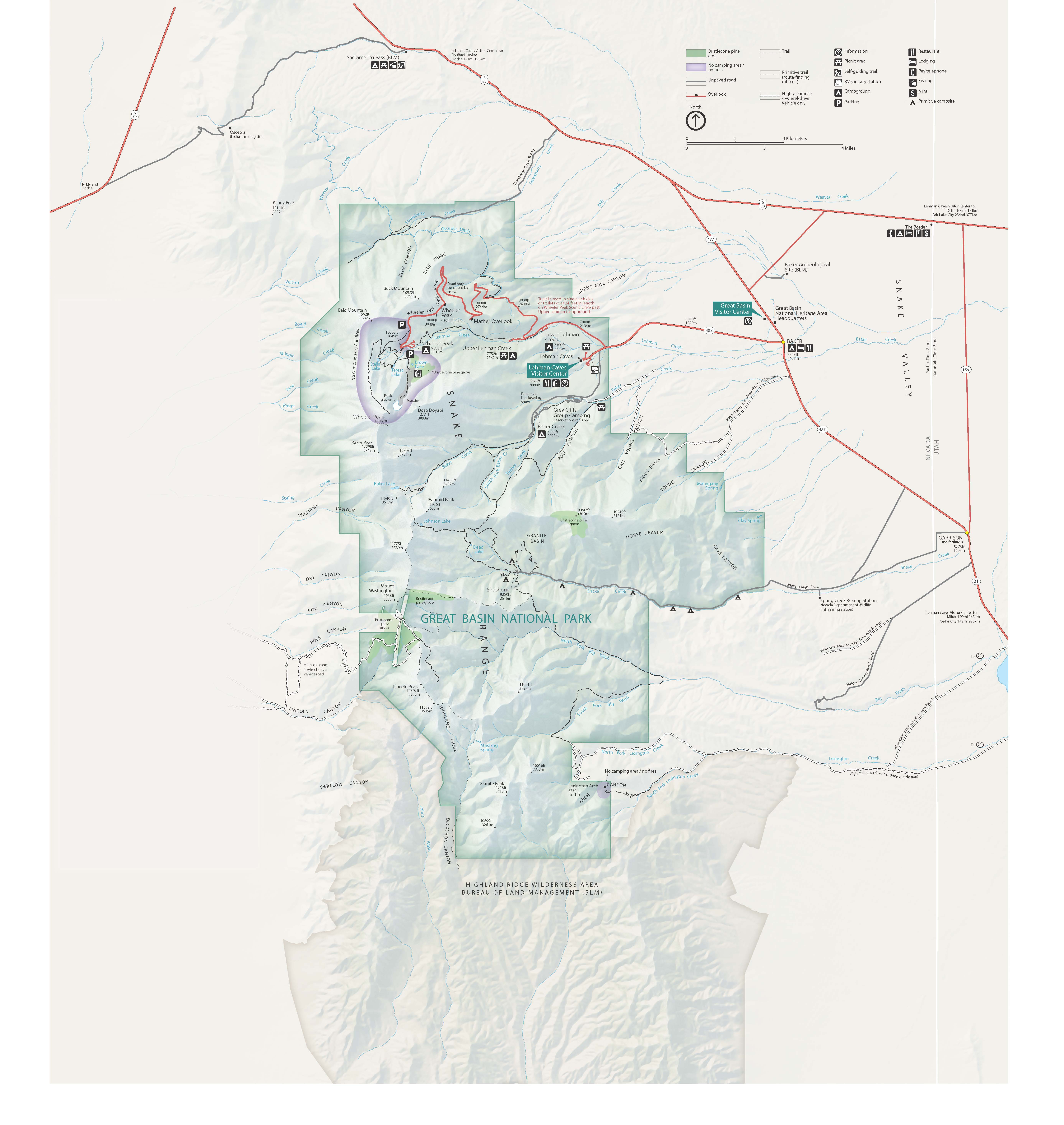
Park Map - Cuyahoga Valley National Park
Park Map
Cuyahoga Valley National Park
JPG Viewable Map File
510.87 KB
2019 screen-viewable file
16.23 MB
2019 Adobe Illustrator print production file
8.31 MB
*downloads in a Zip file.

Riding Run, Perkins, And Furnace Run In Everett. Riding Run Loop, 4.6 Miles, 260 Ft Elevation Change. Perkins Loop, 2.7 Miles, 260 Ft Elevation Change. Furnace Run Loop, 2 Miles, 240 Ft Elevation Change, Stairs. - Riding Run, Perkins, and Furnace Run in Everett. Riding Run Loop, 4.6 miles, 260 ft elevation change. Perkins Loop, 2.7 miles, 260 ft elevation change. Furnace Run Loop, 2 miles, 240 ft elevation change, stairs.
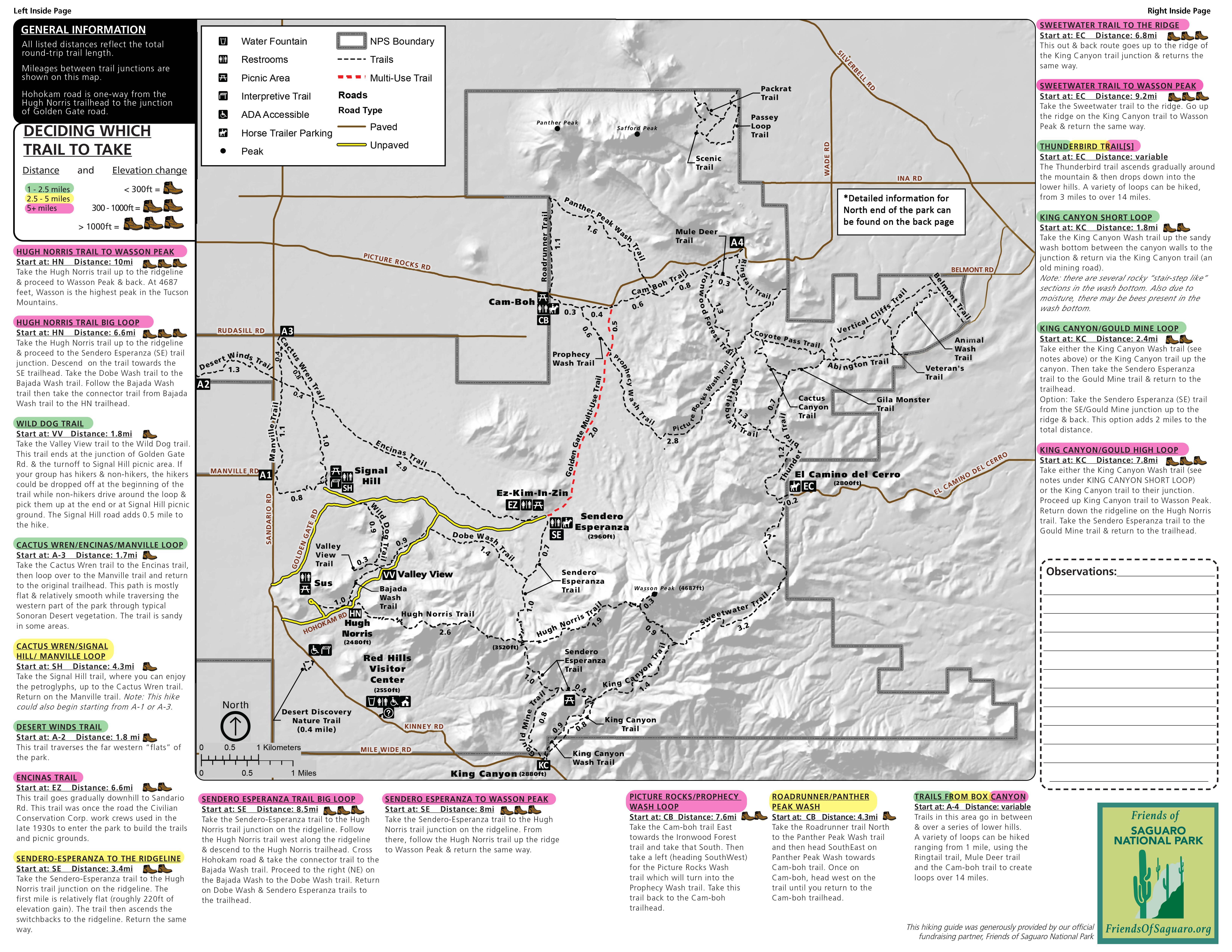
Riding Run, Perkins, And Furnace Run In Everett. Riding Run Loop, 4.6 Miles, 260 Ft Elevation Change. Perkins Loop, 2.7 Miles, 260 Ft Elevation Change. Furnace Run Loop, 2 Miles, 240 Ft Elevation Change, Stairs.
Riding Run, Perkins, and Furnace Run in Everett. Riding Run Loop, 4.6 miles, 260 ft elevation change. Perkins Loop, 2.7 miles, 260 ft elevation change. Furnace Run Loop, 2 miles, 240 ft elevation change, stairs.
Map file from NPS.gov/grba/ website
1.28 MB

Salt Run, Lake, And Cross Country Trails Around Kendall Lake And Hills. Salt Run Trail, 3.3-mile Loop, 160 Feet Elevation Change. Lake Trail, 1 Mile Loop, 20 Feet Elevation Change, Stairs. Cross Country Trail, 2.5-mile Loop, 160 Feet Elevation Change. - Salt Run, Lake, and Cross Country Trails around Kendall Lake and Hills. Salt Run Trail, 3.3-mile loop, 160 feet elevation change. Lake Trail, 1 mile loop, 20 feet elevation change, stairs. Cross Country Trail, 2.5-mile loop, 160 feet elevation change.
Salt Run, Lake, And Cross Country Trails Around Kendall Lake And Hills. Salt Run Trail, 3.3-mile Loop, 160 Feet Elevation Change. Lake Trail, 1 Mile Loop, 20 Feet Elevation Change, Stairs. Cross Country Trail, 2.5-mile Loop, 160 Feet Elevation Change.
Salt Run, Lake, and Cross Country Trails around Kendall Lake and Hills. Salt Run Trail, 3.3-mile loop, 160 feet elevation change. Lake Trail, 1 mile loop, 20 feet elevation change, stairs. Cross Country Trail, 2.5-mile loop, 160 feet elevation change.
Map file from NPS.gov/sagu/ website
2.30 MB

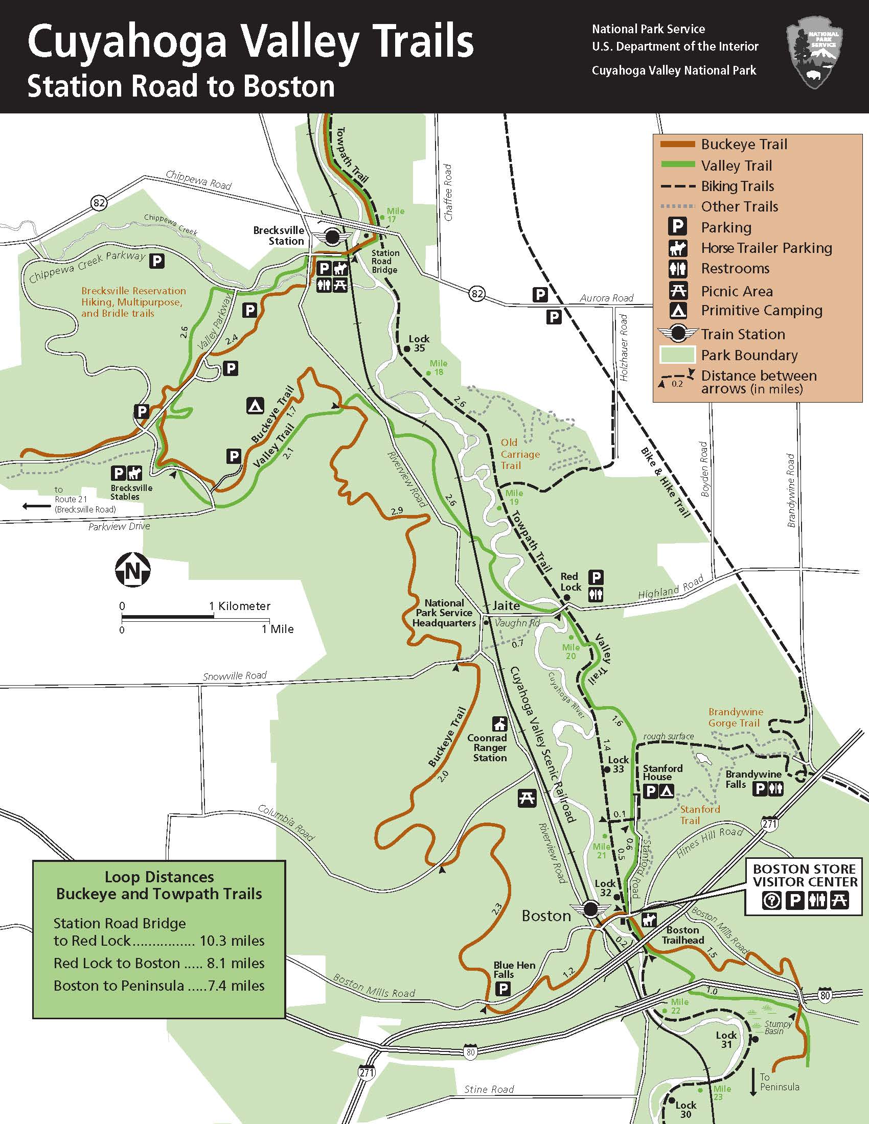
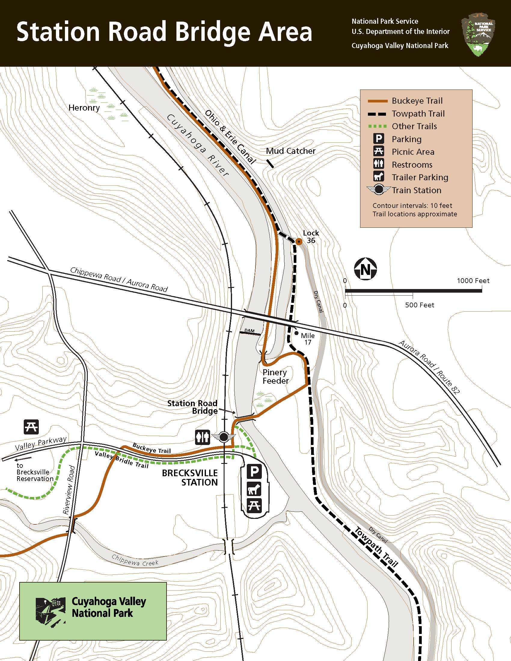
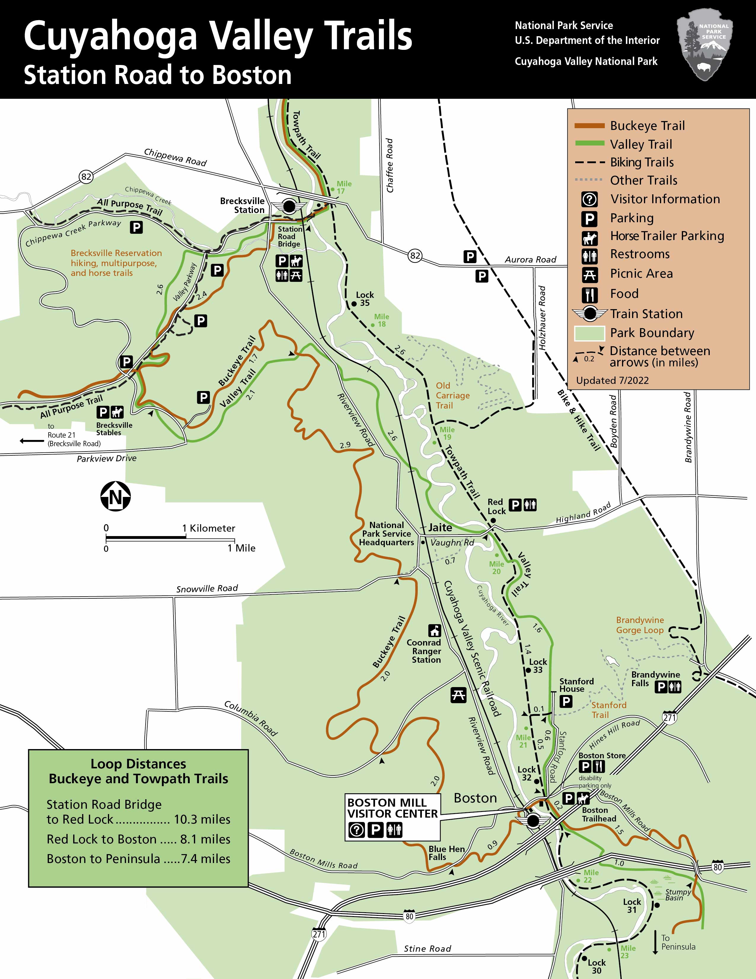
The Major Trails, Roads, And Locations From Station Road Bridge To Boston Mill Visitor Center With Their Amenities. Riverview Road Runs Through The Middle Of The Park With Station Road Bridge, Jaite, And Boston Located Off Riverview Rd. - The major trails, roads, and locations from Station Road Bridge to Boston Mill Visitor Center with their amenities. Riverview Road runs through the middle of the park with Station Road Bridge, Jaite, and Boston located off Riverview Rd.
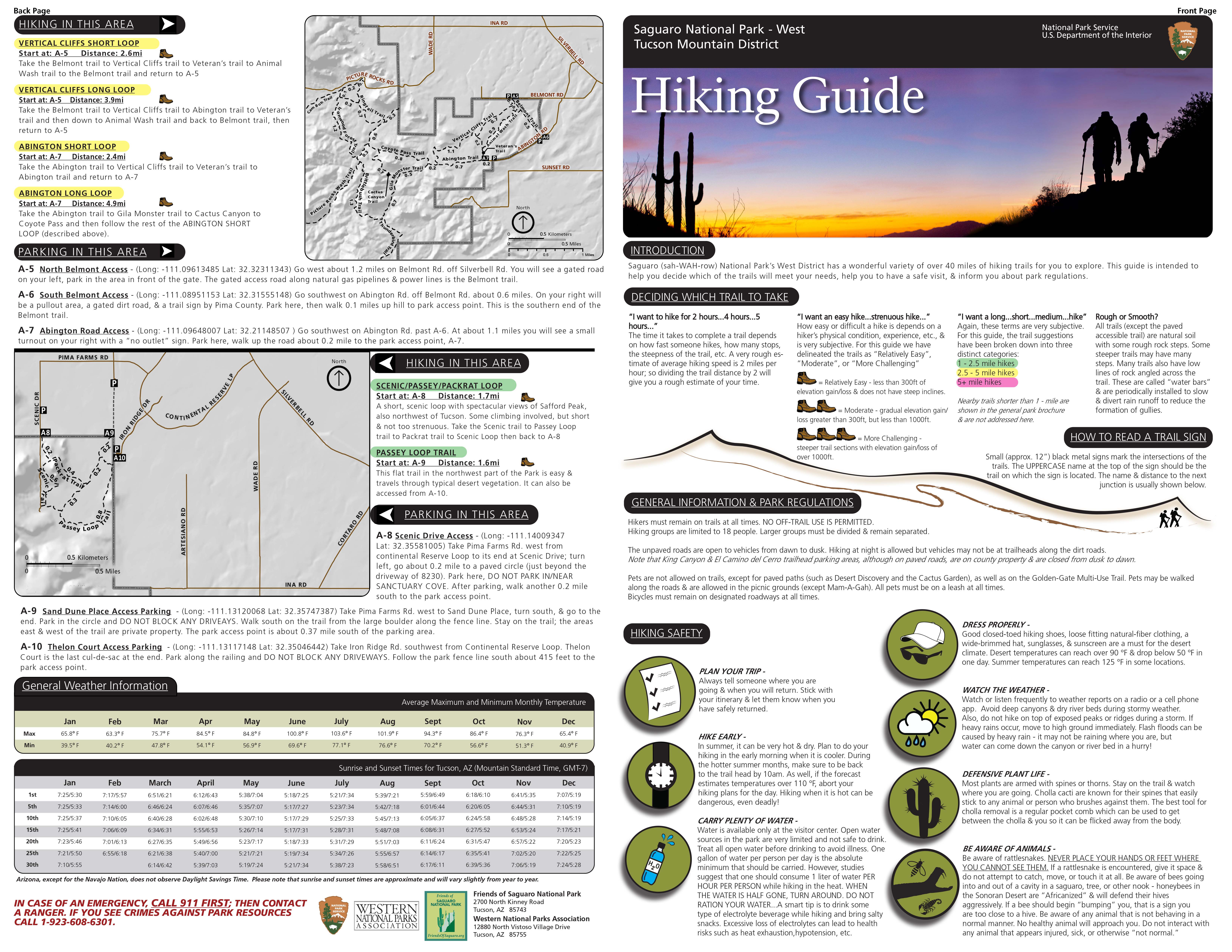
The Major Trails, Roads, And Locations From Station Road Bridge To Boston Mill Visitor Center With Their Amenities. Riverview Road Runs Through The Middle Of The Park With Station Road Bridge, Jaite, And Boston Located Off Riverview Rd.
The major trails, roads, and locations from Station Road Bridge to Boston Mill Visitor Center with their amenities. Riverview Road runs through the middle of the park with Station Road Bridge, Jaite, and Boston located off Riverview Rd.
Map file from NPS.gov/grca/ website
37.47 KB

The Roads And Trails Leading To Brandywine Falls. Brandywine Gorge Loop Begins At The Parking Lot, Loops 1.4 Miles, 160 Feet Elevation Change, Steep Steps. Stanford Trail From Stanford House, 1.5 Miles One Way, 190 Feet Elevation Change, Steep Steps. - The roads and trails leading to Brandywine Falls. Brandywine Gorge Loop begins at the parking lot, loops 1.4 miles, 160 feet elevation change, steep steps. Stanford Trail from Stanford House, 1.5 miles one way, 190 feet elevation change, steep steps.
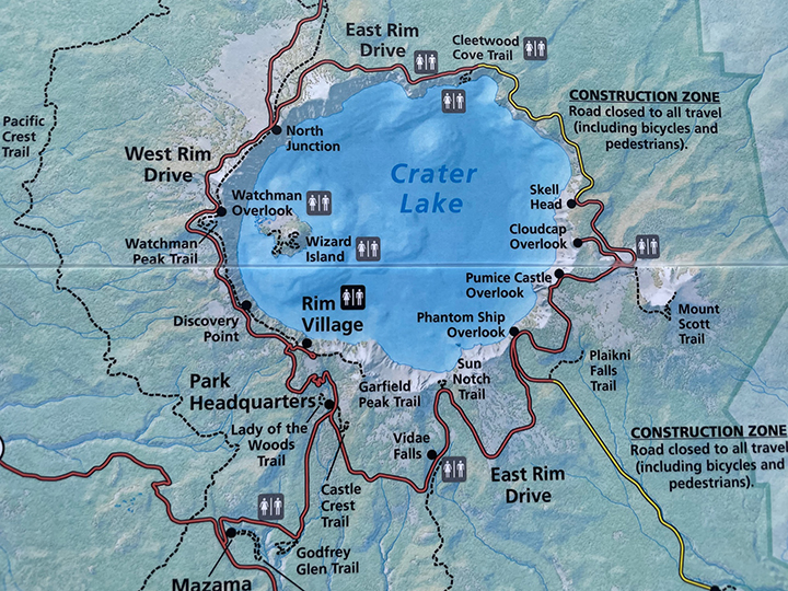
The Roads And Trails Leading To Brandywine Falls. Brandywine Gorge Loop Begins At The Parking Lot, Loops 1.4 Miles, 160 Feet Elevation Change, Steep Steps. Stanford Trail From Stanford House, 1.5 Miles One Way, 190 Feet Elevation Change, Steep Steps.
The roads and trails leading to Brandywine Falls. Brandywine Gorge Loop begins at the parking lot, loops 1.4 miles, 160 feet elevation change, steep steps. Stanford Trail from Stanford House, 1.5 miles one way, 190 feet elevation change, steep steps.
Map file from NPS.gov/sagu/ website
2.50 MB

Trail Map With Black Bar At Top And White Text, " Brandywine Falls Area Trails"; Includes Information About The Roads And Trails Leading To The Falls, Including Brandywine Gorge Loop And Stanford Trail. - Trail map with black bar at top and white text, " Brandywine Falls Area Trails"; includes information about the roads and trails leading to the falls, including Brandywine Gorge Loop and Stanford Trail.
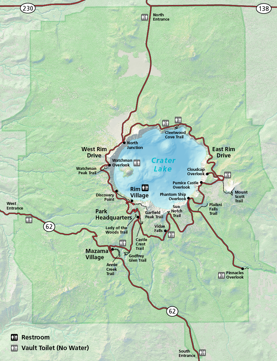
Trail Map With Black Bar At Top And White Text, " Brandywine Falls Area Trails"; Includes Information About The Roads And Trails Leading To The Falls, Including Brandywine Gorge Loop And Stanford Trail.
Trail map with black bar at top and white text, " Brandywine Falls Area Trails"; includes information about the roads and trails leading to the falls, including Brandywine Gorge Loop and Stanford Trail.
Map file from NPS.gov/crla/ website
482.98 KB

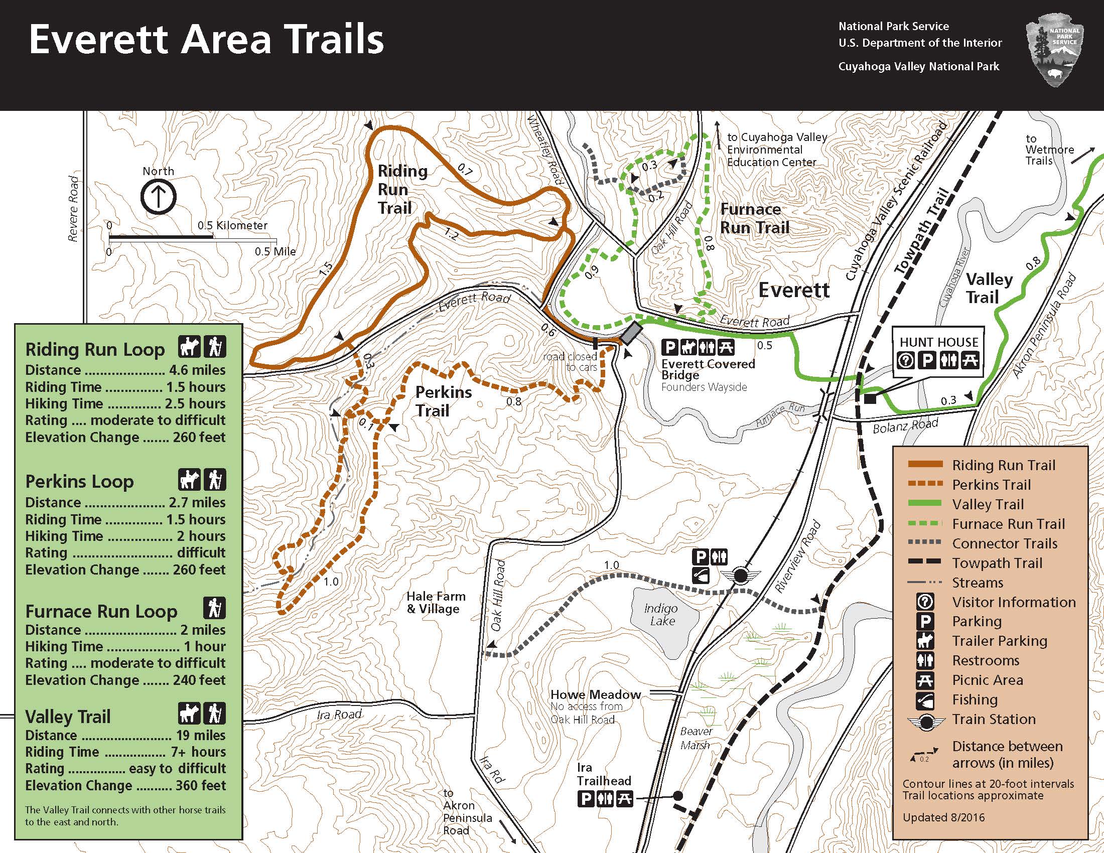
Trail Map With Black Bar At Top And White Text, "Everett Area Trails"; Includes Information About Riding Run Trail, Furnace Run Trail, And Valley Trail. - Trail map with black bar at top and white text, "Everett Area Trails"; includes information about Riding Run Trail, Furnace Run Trail, and Valley Trail.
Trail Map With Black Bar At Top And White Text, "Everett Area Trails"; Includes Information About Riding Run Trail, Furnace Run Trail, And Valley Trail.
Trail map with black bar at top and white text, "Everett Area Trails"; includes information about Riding Run Trail, Furnace Run Trail, and Valley Trail.
Map file from NPS.gov/crla/ website
3.11 MB

Trail Map With Black Bar At Top And White Text, "Wetmore Area Trails"; Includes Information About Wetmore Trail, Butlers Trail, Langes Run Trail, Tabletop Trail, And Valley Trail. - Trail map with black bar at top and white text, "Wetmore Area Trails"; includes information about Wetmore Trail, Butlers Trail, Langes Run Trail, Tabletop Trail, and Valley Trail.
Trail Map With Black Bar At Top And White Text, "Wetmore Area Trails"; Includes Information About Wetmore Trail, Butlers Trail, Langes Run Trail, Tabletop Trail, And Valley Trail.
Trail map with black bar at top and white text, "Wetmore Area Trails"; includes information about Wetmore Trail, Butlers Trail, Langes Run Trail, Tabletop Trail, and Valley Trail.
Map file from NPS.gov/cuva/ website
12.47 MB

Tree Farm Trail Starts From The Horseshoe Pond Parking Lot. A 2.75-mile Loop With 80 Feet Elevation Change. Access The Trail From Major Road, Located South Of Peninsula Off Riverview Road. - Tree Farm Trail starts from the Horseshoe Pond parking lot. A 2.75-mile loop with 80 feet elevation change. Access the trail from Major Road, located south of Peninsula off Riverview Road.
Tree Farm Trail Starts From The Horseshoe Pond Parking Lot. A 2.75-mile Loop With 80 Feet Elevation Change. Access The Trail From Major Road, Located South Of Peninsula Off Riverview Road.
Tree Farm Trail starts from the Horseshoe Pond parking lot. A 2.75-mile loop with 80 feet elevation change. Access the trail from Major Road, located south of Peninsula off Riverview Road.
Map file from NPS.gov/cuva/ website
1.77 MB

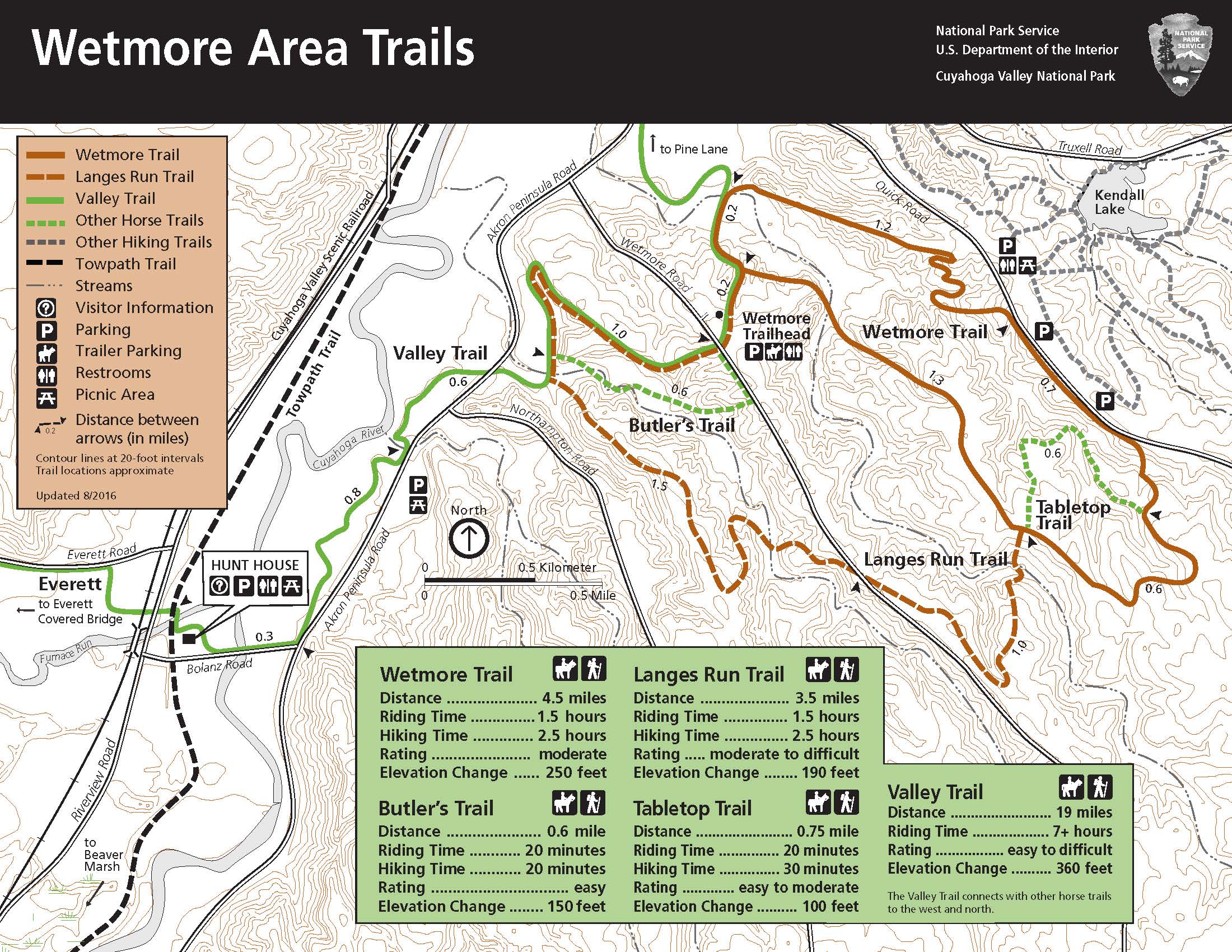
Wetmore Area Trails Allow Horses And Hikers. Wetmore, 4.5 Miles, 250 Ft Elevation Change. Butler’s, 0.6 Miles Each Way, 150 Ft Elevation Change. Langes Run, 3.5 Miles, 190 Ft Elevation Change. Tabletop, 0.75 Miles Each Way, 100 Ft Elevation Change. - Wetmore Area trails allow horses and hikers. Wetmore, 4.5 miles, 250 ft elevation change. Butler’s, 0.6 miles each way, 150 ft elevation change. Langes Run, 3.5 miles, 190 ft elevation change. Tabletop, 0.75 miles each way, 100 ft elevation change.

Wetmore Area Trails Allow Horses And Hikers. Wetmore, 4.5 Miles, 250 Ft Elevation Change. Butler’s, 0.6 Miles Each Way, 150 Ft Elevation Change. Langes Run, 3.5 Miles, 190 Ft Elevation Change. Tabletop, 0.75 Miles Each Way, 100 Ft Elevation Change.
Wetmore Area trails allow horses and hikers. Wetmore, 4.5 miles, 250 ft elevation change. Butler’s, 0.6 miles each way, 150 ft elevation change. Langes Run, 3.5 miles, 190 ft elevation change. Tabletop, 0.75 miles each way, 100 ft elevation change.
Map file from NPS.gov/cuva/ website
1.20 MB